
23 Mountains in TEXAS (Majestic, Gigantic, & Spectacular)
Do you enjoy the thrill of mountain climbing?
Do you like to take a simple hike or watch birds and other wildlife?
If you find yourself nodding and saying yes to these questions, you better start packing and planning your trip to Texas.
There is no denying that Texas is known for numerous things.
It offers stunning scenery, delicious cuisine, and abundant attractions.
This beautiful state is also home to many gorgeous mountains, perfect for climbers, hikers, and anyone looking for an adventure.
Dive in and explore the many mountains that can be seen in this beautiful state.
After reading, you would be excited to lace up your boots, prepare your climbing or hiking gear, and start your trip to Texas.
What are you waiting for?
And by the way, you may also want to check out the most beautiful beaches in Texas.
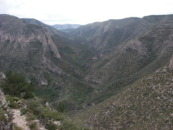
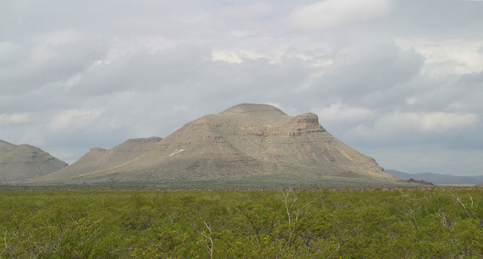
Mountains in Marfa, Texas
1. Davis Mountains (Historical Sites & Scenic Beauty)
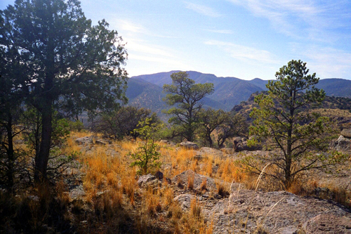
One of the well-known mountains in Texas is the Davis Mountains.
This mountain range is near Fort Davis, where it got its name, and is the perfect place to go for avid campers and hikers.
Fort Davis National Historic Site and Davis Mountains State Park are two of the most popular camping and hiking destinations in the Davis Mountains.
As part of the Chihuahuan Desert, Davis Mountains offer scenic beauty, a deep history, and unique architecture.
You are in for an adventure when you trek the rough terrain of the park.
This feature makes it a significant tourist attraction in Texas.
If you want to get away from the rush and bustle of the city, what are you waiting for?
Visit this secluded yet gorgeous and majestic mountain range.
Address: 25 miles northwest of Fort Davis on Highway 118N
2. Mount Livermore (Highest Davis Peak, Panoramic Views)
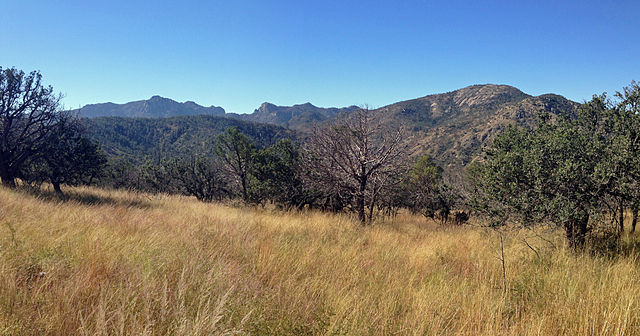
Mount Livermore, named after Major William Livermore, is definitely part of the conversation when people talk about the Davis Mountains.
Why wouldn’t it be?
It has the bragging rights of being the highest point in the Davis Mountains and the fourth most elevated and remote peak in Texas.
The summit of this peak rises to an elevation of 2,533m, making it famous for hiking and climbing.
Mount Livermore is the answer if you are looking for the perfect summit that will give you a panoramic view of the Davis Mountains.
Besides that, it is also known for its scenic view of the Chihuahuan desert and mountains, indeed a sight to behold.
Don’t just sit there and read; the view at the top of Mount Livermore is calling.
Address: 18 miles northwest of Fort Davis, south-central Jeff County, Texas
3. Chinati Mountains (Rich Biodiversity, Unique Geology)
Do you like exploring the unknown and looking for diverse flora and fauna?
If you are, then the Chinati Mountains would be the perfect match for you.
The Chinati Mountains got its name from the Apache term, ch’íná’itíh, which translates as a gate or mountain pass.
Like the Davis Mountains, the Chinati Mountains are also part of the Chihuahuan Desert.
This mountain range is well-known for its stunning scenery, unique geology, and rich biodiversity.
It is popular with hikers, campers, and birdwatchers because it offers a variety of trails and spectacular views.
Anyone who has been on this range would attest to its majestic beauty.
Don’t waste another second; plan your next vacation to this part of Texas and experience everything the Chinati Mountains offer.
Address: South of Pinto Canyon Road, West, Texas
4. Amon – Carter Peak (Scenic View, Sunset Spectacle)
It may sound like the name of a famous singer, but it is far from that.
Amon – Carter Peak is among the best-kept secrets of the Lone Star State.
This peak is within the Chisos Mountains in Big Bend National Park and one of the lowest summits in the Chisos Mountains, at 1,734m.
The hike to the summit is excellent, which is why it is a destination that many love and rave about.
Though if you come here, be prepared for the occasional bushwhacking and mountain lions and black bears in the area.
Also called Carter Peak, this summit is known for its scenic view and breathtaking beauty.
If you like taking visual photos, the sunset on this summit is a view you should not miss.
Address: Big Bend National Park, Southwest, Texas
Also see our article on Lakes in Texas.
Mountains in San Antonio, Texas
1. Emory Peak (Highest Chisos Peak, Varied Flora)
Hiking is an outdoor activity loved by anyone looking to stay fit or wanting to explore nature.
If you are in for an exciting and gratifying hike, Emory Peak offers this along its well-marked path across rocky terrain.
This Peak is the highest in the Chisos mountains, with an elevation of 2,385m.
It was named after William H. Emory, the chief surveyor of the U.S. Boundary Survey team of 1852.
Though it appears to be a minor ridge, do not be fooled, for Emory Peak has a clear visible point slightly higher than most mountain ranges.
If you want to hike on this trail, there is no need for gear, but take great care.
In addition to its beautiful scenery, you would be surprised by the wide range of flora and fauna you would find along the way.
Address: Big Bend National Park, Southwest, Texas
2. Black Hill (Downtown San Antonio View)
It may sound creepy and mysterious but do not be deceived by its name.
Black Hill is located within the Government Canyon State National Area and has one of the best trails in San Antonio.
If you are looking for a trail that offers a scenic road and a rewarding experience, look no further, Black Hill has that for you.
The Black Hill Loop may not lead you to the highest elevation within the park, but you can still see a view of downtown San Antonio.
The view it offers is something to hike for, along with many other adventurous views that await you.
This peak offers a more relaxed hike for those simply looking to get away from all the bustle of the city.
Address: Government Canyon State Natural Area, northwest side of San Antonio, Texas
Also see our article on Hiking Trails in Texas.
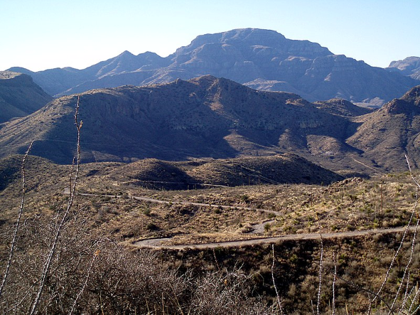
Mountains in Southwest, Texas
1. Guadalupe Mountains (Unique Terrain, 80 Miles of Hiking)
Do you love nature and looking for the perfect spot?
With its unique terrain, the Guadalupe Mountain Range has that to offer.
This mountain range is a famous destination for nature lovers with its rich and varied landscape that serves as a sanctuary for a wide range of wildlife and plant life.
It includes the highest point in Texas, Guadalupe Peak, which stands at 2,667m, and El Capitan.
Many tourists visit the area because it offers 80 miles of hiking trails, including the popular hike to Guadalupe Peak.
This tourist destination offers a variety of outdoor activities, such as hiking and camping.
It is filled with valleys, deserts, woodlands, and rivers, which definitely will attract you and give you a great experience.
What is there to ask for?
Address: Far West Texas on U.S. Highway 62/180
2. Chisos Mountains (Entirely in National Park)
After trekking the Guadalupe Peak, what would be your next destination?
The Chisos Mountains, one of Texas’s well-known mountain ranges, must be next on your list.
This mountain range of the Trans-Pecos region is within the boundaries of Big Bend National Park and covers 40 square miles.
It is the only mountain range in the U.S. that is entirely within a national park, with Emory Peak being the highest summit on the ridge.
The mountain area is primarily forested and is surrounded by the Chihuahuan Desert, which also serves as home to 81 species of birds.
This is the perfect mountain peak if you want to reconnect with nature and like birdwatching.
It offers the ultimate getaway, so get your bags ready and head to this gorgeous mountain range.
Address: Big Bend National Park, Southwest, Texas
3. Mount Pratt (Ancient Coral Reefs, Diverse Wildlife)
Another mountain within the Guadalupe Mountains National Park is Mount Pratt, the seventh-highest summit in Texas at 2,543m.
The Guadalupe Mountains have a complex cave system because of the ancient preserved coral reefs within the range, giving Mount Pratt an interesting underlying.
Though the trail hike on this range is often dry and windy, it is still a good destination for hiking enthusiasts.
If you decide to hike up this trail, bring a gallon of water and be ready for the other challenges the hike brings.
The area’s high elevation and rich surroundings serve as a habitat for black bears, mountain lions, and many trees like the Ponderosa Pine.
There are many potential routes to the peak, but whichever you choose, you’ll surely have an experience you’ll never forget.
Address: Northeast of the Guadalupe Mountains National Park, West, Texas
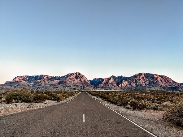
4. El Capitan (Tenth-Highest Peak)
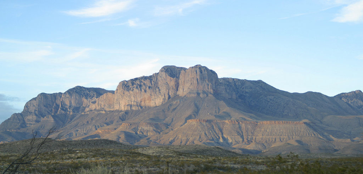
Still, within the Guadalupe Mountains National Park, you can find the tenth-highest Peak in Texas, El Capitan.
This mountain rises above the U.S. 62/180, where its majestic height and striking outline have made it one of the most recognizable sights of the Trans-Pecos region.
It is situated deep within the Chihuahuan Desert and consists of steep mountains and windswept salt cliffs, offering a tremendous challenge to avid hikers.
The dramatic peak and ethereal sunset on its summit are only among the few things that await you on El Capitan.
Though there is no direct ascent to El Capitan’s summit, the climb through Guadalupe Mountain to reach El Capitan is definitely worth it.
So, wait no further; take the next trip to El Capitan and experience all its wonder.
Address: Guadalupe Mountains National Park, West, Texas
5. Caddo Peak (Extreme Activities, Picturesque Scenery)
If you continue through the Guadalupe Mountains, you will find Caddo Peak, one of the tallest peaks in Texas, with an elevation of 2,491m.
Caddo Peak got its name from the Caddo Tribe, which once occupied the area.
This peak is a prime destination if you are an avid fan of extreme outdoor activities like rock climbing.
It is also known for its hiking trails and is a prime spot for bird and animal watchers, making it one of the best tourist spots in West Texas.
Caddo Peak also provides a picturesque scenery of hills, valleys, and forests surrounding the summit and is home to various animal species, including the Guadalupe fescue and the golden eagle.
Everything this mountain has to offer will definitely give you a unique and rewarding experience.
Address: Guadalupe Mountains National Park, West, Texas
Also see our article on Alpaca Farms in Texas.
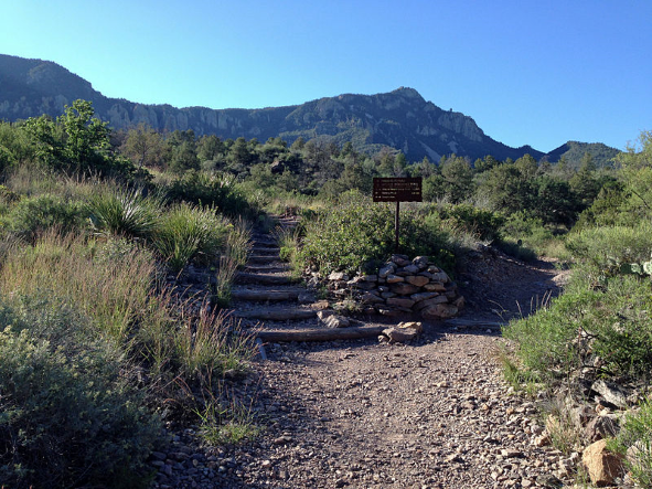
Mountains in El Paso, Texas
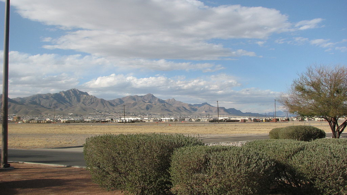
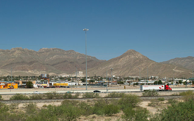
1. North Franklin Mountain (Reddish Color, Scalene-Like Triangle)
If you are looking for a uniquely colored mountain, look no further, North Franklin Mountain has that to offer.
North Franklin is a visible peak from miles away in the Franklin Mountains and is the highest point in El Paso, at 2,192m.
It has a unique reddish color due to the rock’s unusually high levels of oxidized iron.
The mountain is a popular hiking destination because of its well-maintained trail to the summit.
Aside from its unique color, you will also be awed by its scalene-like triangle shape, making it a vital navigation point when traveling.
North Franklin Mountain is the perfect spot to take your favorite recreational activities like hiking and mountain biking.
So, get your bike ready and take a trip to this magnificent mountain.
Address: Franklin Mountains State Park, El Paso, Texas
2. Franklin Mountains (Oldest Precambrian Rocks, Hiking Trail)
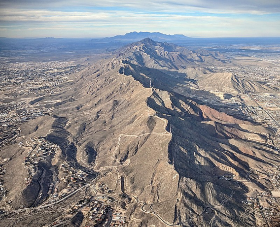
There are many famous mountain ranges in Texas; among them is the Franklin Mountains.
The Franklin Mountains is a small range of 23 miles long and 3 miles wide, mainly composed of sedimentary rocks with igneous impositions.
This range was formed due to a crustal extension related to the Cenozoic Rio Grande Rift, and most of its parts are within the Franklin Mountains State Park.
An interesting fact about the Franklin Mountains is that you can find the oldest Precambrian rocks in this range, which are estimated to be 1.25 billion years old, the oldest in Texas.
Aside from old rocks, this mountain range offers a hiking trail that will lead you to a perfect view at the summit, one that will take your breath away.
Address: Tom Mays Park Access Rd, El Paso, Texas
3. South Franklin Mountain (Jagged Apex, FAA Towers)
Do you know that even mountains have siblings?
Yes, South Franklin Mountain is the sister of North Franklin Mountain.
These mountains are related but not the same, with South Franklin Mountain being the shorter Franklin at 2,069m.
This Peak may not be as well-known as her sister, but it still offers a challenging trek and a panoramic view over El Paso.
South Franklin is easily recognizable because of its jagged and rocky apex, in contrast to North Franklin’s relatively smooth and polished Peak.
This is a good option if you are in for a challenge, a unique experience, and a different view of El Paso.
However, you might get disappointed because the summit is home to many FAA towers; despite that, the experience is still something to relish.
Address: Franklin Mountains State Park, El Paso, Texas
4. Indian Peak (Castner Range, Artillery Range History)
When you go beyond the Franklin Mountains State Park, you will come across the trailhead for Indian Peak.
This peak is in the Castner Mountain Range and was once used as an artillery range by the U.S. Army.
Indian Peak is outside the park, so there is no maintained trail to its summit, but it still has several undiscovered jewels and incredible vistas.
Since the peak is in the Castner Mountain Range, technically U.S. Army property, there have been debates about what to do with it.
The opinion about this is split, but most suggest that the peak should be gifted to Franklin Mountain State Park to be used for recreational purposes.
One thing is sure, though, the Indian Peak is a destination you shouldn’t cross off your travel list.
Address: Castner Mountain Range in northeast El Paso, Texas
Also see our article on Aquariums in Texas.
Mountains in North, Texas
1. Palo Pinto Mountains (Outdoor Recreation, Scenic Beauty)
Have you ever been to the Palo Pinto Mountains, wondering what its name means?
The name Palo Pinto translates to a painted stick in reference to the juniper trees found in the area.
This mountain range is a range of hills in western Palo Pinto County, Texas, which extends to 15 miles and is usually referred to as a much larger area.
The Palo Pinto Mountains are known for outdoor recreational activities like hiking, camping, and fishing.
It offers scenic beauty, and an incredible trail, making it a popular destination for anyone looking for adventure.
If you like different activities, like hiking, picnic, and wildlife viewing, you will enjoy all these in this area; another perfect place to get away from all the busyness of the city.
Address: Western part of Palo Pinto County, Texas
2. Sugarloaf Mountain (Minor Summit, Free Climbing Access)
Sugarloaf Mountain is not any bread or sweets that you have tasted.
This mountain is located at the Franklin Mountain Range and the last peak of the range.
It is connected to South Franklin Mountain but is not part of Franklin Mountains State Park.
This minor summit has an elevation of 1,593m, which is good enough for a decent climb.
Being a minor summit has its perks; among them is free climbing access; however, the trail is not marked, and there is no regulation for its use.
If you are in for a challenge and you are okay with navigating through new terrain, Sugarloaf Mountain is for you.
This mountain will not only get you hungry with its name but also offer you a memorable experience on its terrain.
Address: East side of Franklin Mountain Range in El Paso, Texas
3. Crawford Mountain (Spectacular View, Diverse Flora)
If you are already trekking Palo Pinto, you should take a hike up Crawford Mountain, which was named after Al Crawford.
Located six miles west of Palo Pinto, this Peak offers a new sight to relish; with a summit of only 448m, it is a more accessible mountainous peak.
This is the perfect fit for a simple and relaxing hike, providing you with a magnificent view of the Brazos River up North.
The slopes around this peak are surfaced by clay and sandy loams, which can support scrub bushes, cacti, grasses, and mesquite.
This diverse range of flora will surely add to the many sights you will see on your hike, making you enjoy the trip even more.
So do not just sit there; start planning your trip to Crawford Mountain.
Address: 6 miles west of Palo Pinto in Palo Pinto County, Texas
4. Antelope Mountain (Leisurely Trek, Unique Flora)
Aside from its interesting name, Antelope Mountain has other things to offer.
It can be found 8 miles from Palo Pinto and has a summit of 413m, which offers a more leisurely trek for hikers and climbers.
The area is covered by thin, stony soil supporting scrub bush, mesquite, cactus, and grasses, similar to Crawford Mountain.
Something you should know about this mountain is that the American antelope is among the only two subspecies of the pronghorn antelope around the area.
Antelope Mountain is nearest to Sugarloaf Mountain, so you can visit the area and hike up these mountains if you want to go mountain hopping, camping, or trekking.
Plan your next trip with your friends or family; Antelope Mountain and all its beauty await.
Address: 8 miles from Palo Pinto in west central Palo Pinto County, Texas
Also see our article on Road Trips in Texas.
Mountains in Van Horn, Texas
1. Beach Mountains (Diverse Fauna & Flora)
When you are in Texas, you cannot miss going on a trip to Beach Mountains.
This mountain range is roughly 3 miles north of Van Horn in southwestern Culberson County, Texas, occupying a circular area above the surrounding desert.
The range is one of the multiple isolated mountain ranges that populate the Trans-Pecos region.
Like other nearby ranges, Beach Mountains has a significant geological underlying and offering a wide variety of fauna and flora.
If you want to explore diverse plant life, you will find plants like yucca, mesquite, and other cactus species, in this range.
It also serves as home to rare herds of desert bighorn sheep, which are restricted within the parts of Trans-Pecos, Texas.
This range is a piece of beauty that will give you a different view and appreciation of the Lone Star State.
Address: 2 miles northwest of Van Horn in Southwestern Culberson County, Texas
2. Carrizo Mountain (Tallest Peak, Unique Flora)
One of the many unusual mountain names on this list is Carrizo, which was likely named after the Spanish word for reed grass.
Carrizo Mountain is the tallest Peak in the mountain range of the same name and is located 24 miles southeast of Sierra Blanca.
With an elevation of 1,458m, this Peak is home to some unique flora because its shallow and stony soiled surface is fit for brush, creosote brush, cacti, grasses, oak, and mesquite.
Carrizo Mountain is the right fit for you if you are looking for a place with a scenic trail and a one-of-a-kind hike.
When you reach the top, the view at its summit and the surrounding area is definitely worth it, so take that trip to Carrizo Mountain.
Address: 24 miles southeast of Sierra Blanca, southeastern Hudspeth County, Texas
3. Threemile Peak (Striking Peak, Abundant Resources)
You might have seen this striking peak if you found yourself traveling a few miles off Van Horn, Texas.
Two miles northeast of Van Horn is Threemile Peak, which got its name from its distance from this town.
This peak has an elevation of 1,479m above sea level, with the area almost covered in groves.
The land around the peak is flat in the southeast and hilly in the northwest and is known to have abundant resources within the region surrounding it.
You may not have heard much about this peak, but it offers a good hiking trail for climbers and hikers.
Though it is not as well known, Threemile peak will give you a one-of-a-kind and memorable experience once you have navigated through its trail.
Address: Two miles northeast of Van Horn, Texas
4. Baylor Mountain (Geological Intrigue)
Some of the mountains on this list are named after prominent people, like Baylor Mountains, which got its name from Col. George W. Baylor.
He led the Texas Rangers against the Mescalero Apache in this region in the late 19th century, and this piece of history adds to the richness of the mountains.
The Baylor Mountains are steep and rocky, with shallow and stony soil on the surface, with the highest elevation at 1.696m above sea level.
This peak captured the interest of many geologists because of its rock formations, and you can find some of the oldest rocks in Texas in this mountain range.
Baylor Mountains is ready for you if you are curious, want to make a geological find, or enjoy a good hike.
Address: Two miles north of Van Horn, Texas
If you liked this article, you may also like to read about the best Festivals, Abandoned places, and Spas in Texas.
Looking beyond Texas? Check out our article on the most Majestic Mountains in New York and Florida.